Einstein’s general relativity theory predicts that two ideal clocks will in general run at different rates with respect to a common (coordinate) timescale if they move with a relative velocity or are under the influence of different gravitational fields, which is associated with the relativistic redshift effect. For the usual case of two earthbound clocks at rest, the corresponding clock frequency shift or relativistic redshift effect is directly proportional to the gravity (gravitational plus centrifugal) potential difference at both sites, where one part in 1018 clock frequency shift corresponds to about 0.1 m2s-2 in terms of the gravity potential difference, which is equivalent to 0.01 m in height. Hence, geodetic knowledge of heights and the Earth’s gravity potential can be used to predict frequency shifts between local and remote (optical) clocks, and vice versa, frequency standards can be used to determine gravity potential differences. The latter technique has variously been termed “chronometric levelling”, “relativistic geodesy”, and “chronometric geodesy”. It offers the great advantage of being independent of any other geodetic data and infrastructure, with the perspective to overcome some of the limitations inherent in the classical geodetic approaches. For example, it could be used to interconnect tide gauges on different coasts without direct geodetic connections and help to unify various national height networks, even in remote areas.
This project connects the areas of time metrology with optical clocks and classical physical geodesy. In the first instance, the classical geodetic and the chronometric levelling results are used for a mutual validation, which is important to build confidence in the new generation optical clocks and the associated uncertainty budgets as well as in view of future geodetic applications of the optical clocks, while later on all results shall be combined to obtain optimal geopotential estimates. In this context, geodetic knowledge on the gravity potential is first derived from the geometric levelling technique (together with gravity observations) and secondly from GNSS (Global Navigation Satellite System) positions and the results from gravity field modelling (e.g., disturbing potential, (quasi)geoid, based on the geodetic boundary value problem (GBVP) theory), the latter procedure being also denoted as the GNSS/GBVP or GNSS/geoid approach; both techniques have their own particular strengths and limitations, with the geometric levelling approach giving superior accuracies over shorter distances (few km), while the GNSS/GBVP approach should be beneficial over longer distances (1000 km and more).
Project C04 aims at providing the relativistic redshift corrections and the corresponding gravity potential values with best possible accuracy. For this purpose, GNSS and levelling observations have been performed at the relevant clock sites, and emphasis is put on the development of an improved high-resolution (quasi)geoid model for Central Europe, targeting in the long term an accuracy of 1 cm or better. This includes a revised mathematical modelling regarding the observation equations, the consideration of the atmosphere and the topography, the use of a high-degree reference geopotential model, the combination, data weighting and error estimation procedure, as well as a closed-loop simulation and software test.
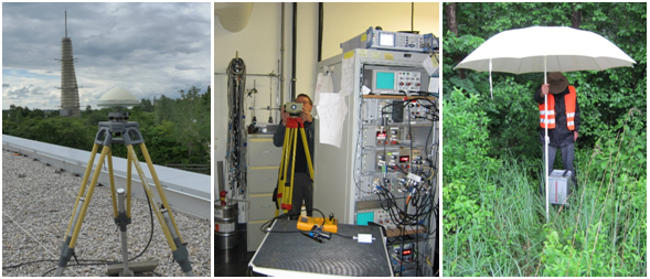
The pictures below show GNSS, levelling and gravimetric measurements at and around the Max-Planck-Institut für Quantenoptik (MPQ), Garching, one of the planned clock sites within geo-Q.
Principal Investigator
Schneiderberg 50
30167 Hannover


